Community Priorities Shape Development Plan for Eight Perachara Villages
An estimated Tk 23.77 million plan proposes water, sanitation, access and agricultural improvements across eight villages covering 847 households.
Community consultations and social mapping have informed a proposed infrastructure development plan for eight paras (villages) in the Perachara Cluster of Khagrachhari Sadar Upazila. The plan addresses drinking water shortages, sanitation gaps, difficult village access and constraints to agricultural production under the Community Infrastructure (CI) Component of the Climate Resilient Livelihoods Improvement and Water Management in the CHT Sector Project (CRLIWM-CHT Sector Project).
Participatory para profiling and problem prioritisation helped identify interventions suited to each village’s settlement patterns, water sources, agricultural land and access needs.
According to the Feasibility Study Report (FSR), the Perachara Cluster comprises eight paras under Perachara and Bhaibonchhara Unions of Khagrachhari Sadar Upazila. The cluster has a total of 847 households with a combined population of 4,023. The eight paras are Beltali Para, 8 Mile Joutho Khamar Para, Polukya Para, Aladhan Para, Mayung Tuiklu Para, Purbo Singinala Para, Nilkantha Para and Chotobari Para.
Communities Identify Their Priorities
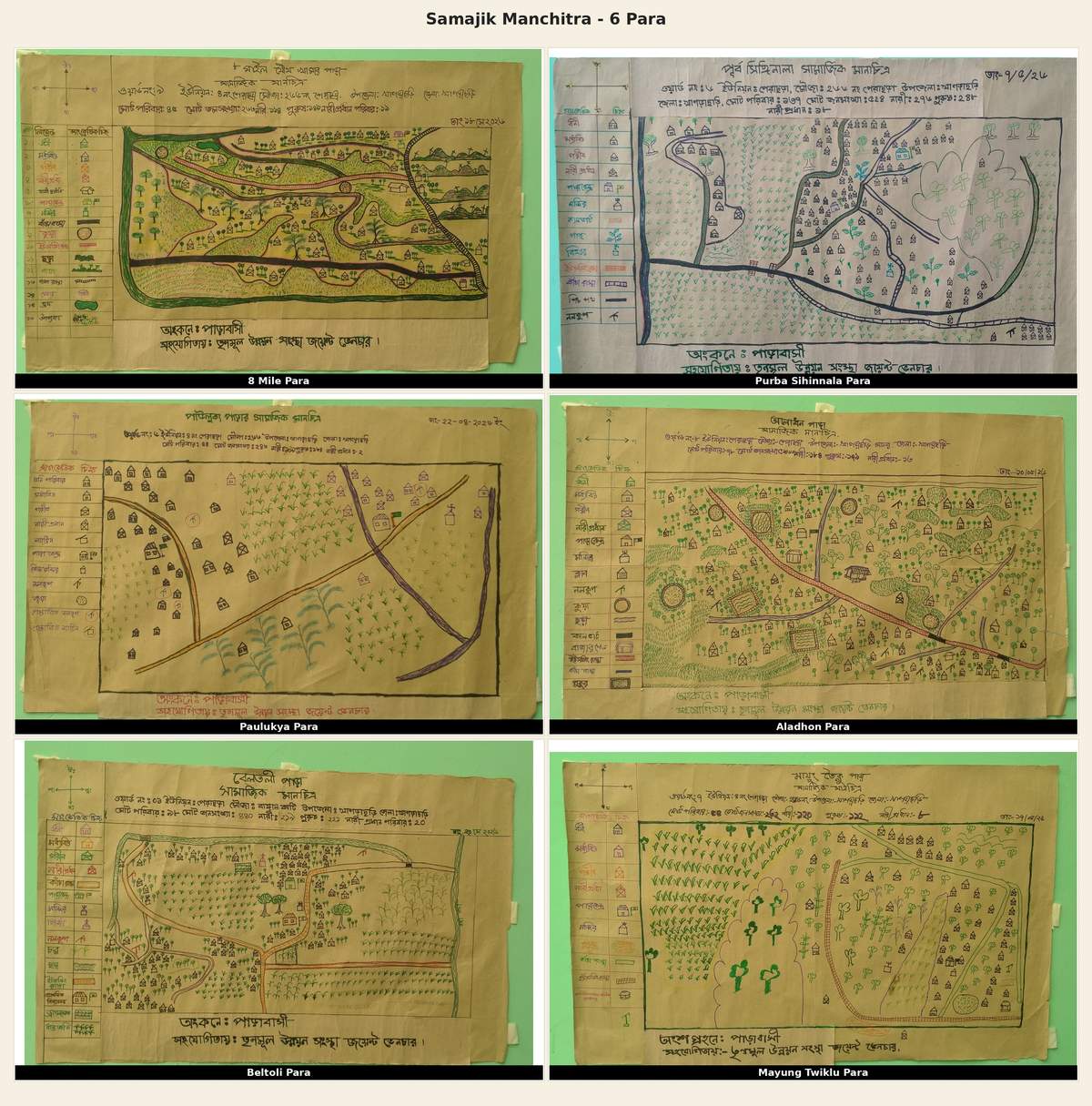
Social mapping exercises were conducted in each para to identify settlements, households, water sources, agricultural lands, roads, footpaths, educational institutions and other community assets. Discussions with local residents also helped identify infrastructure gaps and determine development priorities.
The assessment revealed that, although some paras have existing water sources, access to safe drinking water remains limited for poor and vulnerable households. In some communities, residents still depend on streams and natural water sources. Internal pathways in several paras become muddy and difficult to navigate during the rainy season. Meanwhile, agricultural production is constrained by inadequate irrigation facilities, a shortage of farming equipment and insufficient supporting infrastructure.
Beltali Para: Focus on Safe Drinking Water and Agricultural Irrigation

Community-drawn social map of Beltali Para, showing local resources, settlements and community planning priorities.
Located on the western bank of the Chengi River, Beltali Para has 98 households. The absence of a bridge over the river has long affected connectivity with neighbouring areas. Although the para has 42 tube wells, most are privately owned. As a result, 14 poor and vulnerable households lack access to safe drinking water and depend on nearby streams and the Chengi River.
Agricultural activities in the para are also largely dependent on rainfall. The existing irrigation canal is partially damaged, leaving a significant portion of agricultural land uncultivated during the dry season.
To address these challenges, the proposed interventions include one deep tube well with a pipeline network, solar panels for five households, 250 metres of underground HDPE irrigation pipeline, two 12-horsepower power tillers, two mud pumps, one paddy thresher and one U-slab culvert.
8 Mile Joutho Khamar Para: Solar-Powered Water Supply for 45 Households

Community-drawn social map of 8 Mile Joutho Khamar Para, showing local resources, settlements and community planning priorities.
Situated across hilltops and slopes, 8 Mile Joutho Khamar Para has 45 households. The major challenge faced by the community is the lack of access to safe drinking water. There are no tube wells or piped water supply facilities in the para. Residents collect water from streams, wells and natural water sources located downhill. Some households have to walk between 500 and 700 metres to collect water.
The long distance involved in water collection places an additional burden on women and children, while the availability of water varies between the rainy and dry seasons.
To improve access to safe drinking water, the proposed interventions include two deep tube wells with submersible pumps, water storage tanks, pipeline networks and solar-powered facilities.
In addition, 306 metres of brick flat soling pathways and 30 metres of RCC footpaths have been proposed to improve internal connectivity.
Polukya Para: Improved Water Supply, Sanitation and Agricultural Mechanisation
Polukya Para has 54 households and faces shortages of safe drinking water and hygienic sanitation facilities. Some of the existing ring wells are non-functional, while most households use pit latrines, creating potential health and water contamination risks.
Based on community needs, the proposed interventions include two deep tube wells with submersible pumps, water storage tanks and pipeline networks. The plan also includes 47 hygienic latrines for poor and vulnerable households and two 12-horsepower power tillers to support agricultural activities.
Aladhan Para: Expanding Access to Safe Water and Improving Connectivity

Community-drawn social map of Aladhan Para, showing local resources, settlements and community planning priorities.
Aladhan Para has 78 households. Agriculture, fruit cultivation and livestock rearing are among the major livelihood activities of its residents.
Although tube wells are available in the para, excessive iron content in the water is a concern. The community also faces limitations in connectivity and access to safe drinking water.
To address these issues, the proposed interventions include 300 metres of brick flat soling pathways and two deep tube wells with piped water supply facilities.
Mayung Tuiklu Para: Improving Hill Pathways and Access to Water
Mayung Tuiklu Para has 54 households. Residents primarily depend on agriculture, livestock rearing and wage labour for their livelihoods.
Although privately owned tube wells are available in the para, they are not accessible to all households. Consequently, some families face difficulties obtaining safe drinking water. The unpaved internal pathways also become difficult to use during the rainy season.
The proposed infrastructure interventions include one shallow tube well, 150 metres of RCC footpaths, 150 metres of brick flat soling pathways and 160 metres of guide walls.
These facilities are expected to improve community mobility and access to water collection points once implemented.
Purbo Singinala Para: Strengthening Agricultural Productivity and Internal Connectivity

Community-drawn social map of Purbo Singinala Para, showing local resources, settlements and community planning priorities.
Purbo Singinala Para is one of the larger communities in the cluster, with 137 households. The para is inhabited by Chakma and Marma communities.
Of the 101 tube wells recorded in the para, 100 are functional. However, 33 vulnerable households remain without access to tube well facilities. The community also faces a shortage of power tillers and other agricultural equipment. Some sections of the existing brick-soling pathways are in poor condition.
To address these challenges, the proposed interventions include 500 metres of brick flat soling pathways, three shallow tube wells, one deep tube well with a pipeline network, two 12-horsepower power tillers, one paddy thresher, 32 hygienic latrines, one U-slab culvert and 170 metres of guide walls.
Nilkantha Para: Expanding Irrigation and Improving Rural Connectivity
Nilkantha Para has 250 households. Special emphasis has been placed on improving agricultural production and internal connectivity in this community.
To expand irrigation facilities for agricultural land and make movement easier for local residents, the construction of a 700-metre irrigation canal and 600 metres of brick flat soling pathways has been proposed.
Chotobari Para: Expanding Safe Drinking Water and Sanitation Facilities
Located in Bhaibonchhara Union, Chotobari Para has 131 households. The community faces challenges related to safe drinking water, non-functional water sources and limited access to hygienic sanitation facilities. A shortage of irrigation equipment has also been identified as a constraint to agricultural productivity.
To address these issues, the proposed interventions include four deep tube wells, a submersible pump, a water supply and storage tank system, and 60 hygienic latrines.
Proposed Investment and Infrastructure
According to the FSR summary, the proposed infrastructure development interventions across the Perachara Cluster include:
-
1,856 metres of brick flat soling pathways;
-
180 metres of RCC footpaths;
-
150 metres of L-drains;
-
330 metres of guide walls;
-
139 hygienic latrines;
-
Four shallow tube wells;
-
Two U-slab culverts;
-
700 metres of irrigation canals; and
-
250 metres of underground irrigation pipelines.
In addition, the plan includes five deep tube wells, six piped water supply systems with submersible pumps and water storage tanks, two additional deep tube wells with solar-powered facilities, six power tillers, two mud pumps, two paddy threshers and five solar panels.
According to the Feasibility Study Report, the total estimated cost of the proposed infrastructure development interventions in the Perachara Cluster is Tk 23,766,172.63 (approximately Tk 23.77 million). The interventions are planned to be implemented through three separate packages.
Community Participation and Next Steps
Community members have helped identify and prioritise the proposed works, bringing local needs into the planning process.
The needs of women, poor households, female-headed households, persons with disabilities and other vulnerable groups have also been considered. The project further plans to involve local communities in environmental and social safeguards, implementation processes and the operation and maintenance of infrastructure facilities.
The proposed works are intended to improve access to essential services and support agricultural livelihoods and climate resilience. The expected benefits will depend on implementation and the continued operation and maintenance of the facilities.
Source: Feasibility Study Report (FSR), Perachara Cluster Subproject, Community Infrastructure (CI) Component, CRLIWM-CHT Sector Project, August 2026.